
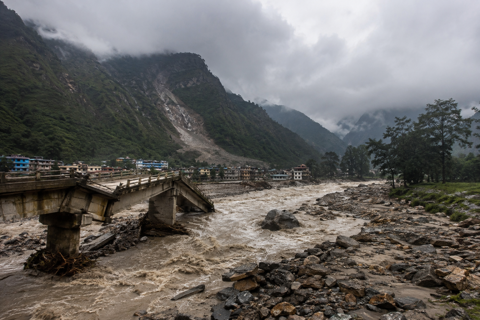
The most important fact about the August 2026 Nepal floods is also the easiest to miss: this was not simply a case of heavy monsoon rain overwhelming a river.
The disaster that struck Nepal’s Rasuwa district on August 26 was driven by a sudden high-altitude geological event that appears to have sent an enormous pulse of water, rock, ice and sediment into the Bhote Koshi river system. Preliminary scientific assessments point to an ice-rock avalanche in the Lhende Khola area, with reports also linking the event to a possible earthquake. The resulting flood wave moved with such force that river levels downstream reportedly rose by as much as nine metres in 30 minutes.
That distinction matters. If Nepal treats the catastrophe as another monsoon flood, it will prepare for the wrong hazard.
Here are 10 facts that explain what happened, why the August 2026 Nepal floods became so destructive, and what the Himalayan region should learn from them.
1. The August 26 flood began as a mountain hazard, not a conventional river flood
The first critical fact is the source of the water and debris.
The flood struck the Bhote Koshi River in northern Nepal’s Rasuwa district at roughly 8:30 to 9:00 am local time on August 26. The river then carried the surge downstream toward the Trishuli system, affecting settlements and infrastructure in Rasuwa, Nuwakot and other districts.
Scientists from the International Centre for Integrated Mountain Development are investigating whether a large ice-rock avalanche entered the Lhende Khola, a tributary connected to the Bhote Koshi. Reuters reported that an earthquake-induced ice-rock avalanche is suspected of having triggered the event.
This is an important distinction from a standard monsoon flood.
Rainfall can raise river levels progressively. An avalanche or landslide entering a confined Himalayan river valley can create a much faster chain reaction. Rock and ice enter the river, displace water, mobilise sediment and debris, and can create temporary blockages. If such a blockage fails, downstream communities may receive a sudden flood pulse with little practical warning.
2. The speed of the flood was one of its most dangerous characteristics
The August 2026 Nepal floods demonstrate why flood risk cannot be measured only by the amount of rainfall.
ICIMOD reported that water levels on the Trishuli River at Galchchi reportedly rose by up to nine metres within 30 minutes. At Malekhu, the rise was reported at around seven metres over a similar period.
That is an extraordinary rate of change for communities living beside a river.
A village may have a functioning warning system and still have almost no usable evacuation window if the warning arrives after the flood wave has already formed upstream.
This changes the engineering question from “How much rain can the river handle?” to “How quickly can a community detect, communicate and act on a sudden upstream disturbance?”
That is a far more demanding problem.
3. Hundreds of people were initially unaccounted for, including foreign travellers
The human toll remains fluid because communications were disrupted and several affected areas became difficult to access.
By August 26, Nepal police were reporting at least 95 deaths. Earlier official and media assessments had reported substantially lower numbers as rescue teams reached affected locations. The Associated Press later reported 95 deaths in Nepal and three deaths in Tibet, while noting that hundreds remained missing.
The Nepal Tourism Board separately reported 384 tourists and travellers out of contact, including 291 foreign nationals and 93 Nepali citizens.
The missing-person figure is particularly significant because the disaster occurred along a major route used by people travelling toward Gosainkunda and the Kailash Mansarovar pilgrimage route.
Indian nationals made up a substantial portion of the foreign travellers reported missing. Preliminary lists identified 105 Indian nationals among those unaccounted for.
The lesson is not simply that tourism was caught in a disaster. It is that disaster planning in remote Himalayan corridors now has to account for highly mobile populations whose location may be known to private travel operators but not necessarily integrated into government emergency systems.
4. The destruction crossed the Nepal-China border
This was never only a Nepalese disaster.
The same mountain system connects Nepal and Tibet, and the flood and associated mudslide severely affected China’s Gyirong County. Gyirong Port, an important land crossing between China and Nepal, was hit by a mudslide, disrupting roads, communications and electricity.
China reported deaths and hundreds of people missing on its side of the border. The Associated Press reported three deaths and 265 people missing in China in addition to the casualties reported in Nepal.
That makes the disaster a textbook example of a transboundary mountain-risk problem.
The hazard does not care where the political boundary lies. A landslide, avalanche, glacial lake or river blockage upstream can create consequences hundreds of kilometres away and across an international frontier.
Nepal, China and India therefore need disaster-warning arrangements that operate across borders rather than stopping at national boundaries.
5. The flood destroyed critical infrastructure, not just homes
The physical damage is unusually important because the affected corridor contains transport, energy and border infrastructure.
Reports indicate that roads, bridges, markets, security posts, customs facilities and power infrastructure were damaged or destroyed. The Nepal government has also reported damage to dozens of kilometres of roads and multiple motorable bridges.
The Nepal Electricity Authority said roughly 430 megawatts of generation capacity, including hydropower and solar facilities, had been damaged or disrupted.
This exposes a strategic vulnerability in Nepal’s development model.
Hydropower is central to Nepal’s economic ambitions. Yet many power projects sit in precisely the terrain where rivers, landslides, avalanches and debris flows are most aggressive.
A hydropower plant can be designed to withstand a particular range of river flows. It is much harder to design for a sudden wall of water carrying boulders, trees and enormous quantities of sediment.
The financial consequences can therefore extend well beyond the cost of rebuilding a few damaged facilities.
6. Climate change may be part of the risk equation, but it did not cause this flood by itself
This distinction needs to be made carefully.
It is tempting after any Himalayan flood to attribute the event directly to climate change. That would be scientifically premature in this case.
The immediate trigger identified by preliminary assessments is geological. ICIMOD is investigating an ice-rock avalanche, while Reuters reported that authorities and experts suspected an earthquake-induced avalanche in the Lhende Khola.
Climate change matters because it is altering the background conditions in which these hazards occur.
The Himalayas are warming rapidly. Glacier retreat is changing high-altitude landscapes, while the formation and expansion of glacial lakes can increase the potential for glacial lake outburst floods. The World Bank has warned that accelerated glacier melting can amplify flooding risks in Nepal and across the wider Himalayan region.
So the scientifically defensible argument is not that climate change “caused” the August 26 flood.
It is that climate change is changing the hazard environment and increasing uncertainty around the behaviour of high-mountain systems.
That distinction should guide public policy.
7. Nepal already knew it was vulnerable to cascading disasters
The August 2026 catastrophe did not emerge from a country with no warning about its underlying exposure.
Nepal’s geography combines steep slopes, powerful monsoon rainfall, unstable mountain terrain, dense settlement along river corridors and limited access to remote areas.
The World Bank has identified floods, landslides, avalanches and glacial hazards as major climate and disaster risks for Nepal. Its research also highlights how economic vulnerability magnifies the effect of physical hazards.
Nepal has also experienced cascading disasters before.
The 2021 Melamchi flood, for example, demonstrated how rainfall, landslides, debris and river flooding can combine to destroy communities and critical infrastructure. The World Bank subsequently argued that Nepal needed better high-altitude observation systems and stronger early-warning capabilities.
The uncomfortable lesson is that Nepal does not primarily suffer from a lack of knowledge about disaster risk.
It suffers from the difficulty of translating knowledge into infrastructure, land-use decisions, monitoring networks and rapid action at the local level.
8. Early warning must move upstream, higher and faster
This may be the most important operational lesson from the August 2026 Nepal floods.
Traditional flood-warning systems concentrate on rainfall and river gauges. Those systems remain essential. They are not enough for Himalayan cascading hazards.
A modern warning architecture needs to combine:
- High-altitude weather stations
- River-level and flow sensors
- Seismic monitoring
- Glacier and glacial-lake surveillance
- Satellite imagery
- Automated landslide detection
- Real-time communications
- Local evacuation protocols
The World Bank has already highlighted the value of drones, satellite imagery and geospatial analysis for identifying landslide and flood risks in Nepal.
The critical change is to monitor the hazard where it begins rather than where the flood eventually arrives.
If an avalanche enters a river 20 or 30 kilometres upstream, communities downstream should not be waiting for their local river gauge to tell them that the water has arrived.
The warning has to travel faster than the flood.
9. A second flood risk shows why temporary blockages are so dangerous
One of the most serious secondary risks is not the water that has already passed.
It is water that may still be trapped upstream.
Reuters reported that authorities were concerned about a potential second flood because of an upstream blockage in the Lhende Khola.
This is a classic Himalayan hazard mechanism.
A landslide or avalanche can dam a river temporarily. Water then accumulates behind the blockage. If the barrier fails suddenly, a second flood wave can travel downstream, sometimes with greater destructive force than the initial event.
This is why rescue operations cannot simply focus on clearing roads and recovering victims after the first flood.
Emergency teams need continuous upstream surveillance.
That means satellite radar, drone reconnaissance, helicopter observation where weather permits and rapid hydrological modelling should become part of the standard response package after a major mountain flood.
10. The biggest lesson is that Nepal needs a multi-hazard infrastructure strategy
The August 2026 Nepal floods expose a planning problem that extends far beyond flood protection.
A road in the Himalayas is not exposed only to floods. It can be destroyed by landslides, debris flows, avalanches, earthquakes or a combination of these hazards.
A bridge is not merely a transport asset. It can become the point at which an entire community loses access to hospitals, markets and emergency services.
A hydropower plant is not only an energy investment. Its location places it within a wider geological and hydrological system.
This is why infrastructure planning needs to shift from single-hazard engineering toward multi-hazard risk assessment.
Nepal has already begun moving in that direction. In 2024, the World Bank approved $150 million in contingent financing and policy support aimed at strengthening disaster resilience, early warning, risk-informed infrastructure investment and emergency response. In 2025, the Asian Development Bank, World Bank and Swiss Agency for Development and Cooperation announced a broader partnership to strengthen disaster-risk management and climate-resilient infrastructure in Nepal.
The question now is whether that institutional architecture can move quickly enough to match the speed at which Himalayan hazards are changing.
What the August 2026 Nepal floods teach the rest of South Asia
The most useful way to understand this disaster is not as an isolated natural catastrophe.
It is a warning about interconnected risk.
A geological event high in the Himalayas can become a flood downstream. The flood can become a landslide. The landslide can destroy a highway. The destroyed highway can isolate communities. Damaged power infrastructure can create a second economic shock. A border crossing can be shut down. Tourists and pilgrims can become stranded or unaccounted for. And a disruption in one country can create warnings and downstream risks in another.
That chain can unfold within hours.
South Asia’s disaster-management systems were largely built around hazards that could be observed separately. The Himalayan environment increasingly demands systems designed around hazards that cascade into one another.
For Nepal, the priority should be clear.
Build monitoring systems higher in the mountains. Link them across borders. Put flood, landslide, avalanche and seismic data into the same operational warning system. Require major infrastructure projects to account for debris flows and cascading hazards rather than river levels alone. Give local communities evacuation instructions that are simple enough to act on within minutes.
And treat the location of roads, settlements, hydropower facilities and tourism routes as disaster-risk decisions, not merely development decisions.
The August 2026 floods have shown that the most dangerous Himalayan disasters may not announce themselves with days of rain. Sometimes the decisive event begins above the river, out of sight, and reaches the people below in minutes.
Nepal’s next stage of resilience will depend on recognising that reality before the next mountain gives way.
References & Sources
International Centre for Integrated Mountain Development, “Major flash flood sweeps through Nepal’s Rasuwa district, raising fears of further downstream flooding,” August 26, 2026. ICIMOD source
Reuters, “What triggered the catastrophic flood on the Nepal-Tibet border?”, August 26, 2026. Reuters source
Associated Press, “At least 98 killed and hundreds missing after flash floods in Nepal and China,” August 26, 2026. Associated Press source
The Kathmandu Post, “What we know about the Bhotekoshi flood so far,” August 26, 2026. Kathmandu Post source
Radio Nepal, “Bhotekoshi flood: 384 tourists lose contact in Rasuwa,” August 26, 2026. Radio Nepal source
World Bank, “Climate Risks, Exposure, Vulnerability and Resilience in Nepal,” 2023. World Bank report
World Bank, “In Nepal, 2 Major Climate Disasters in a Single Year Highlight the Need to Build Resilience,” 2022. World Bank climate resilience analysis
World Bank, “World Bank Approves $150 Million to Strengthen Nepal’s Disaster Response and Resilience,” 2024. World Bank disaster resilience program
World Bank, “ADB, IDA, and Switzerland Partner to Strengthen Nepal’s Disaster Risk Management and Build Climate-Resilient Infrastructure,” 2025. World Bank partnership announcement
About The Author


