
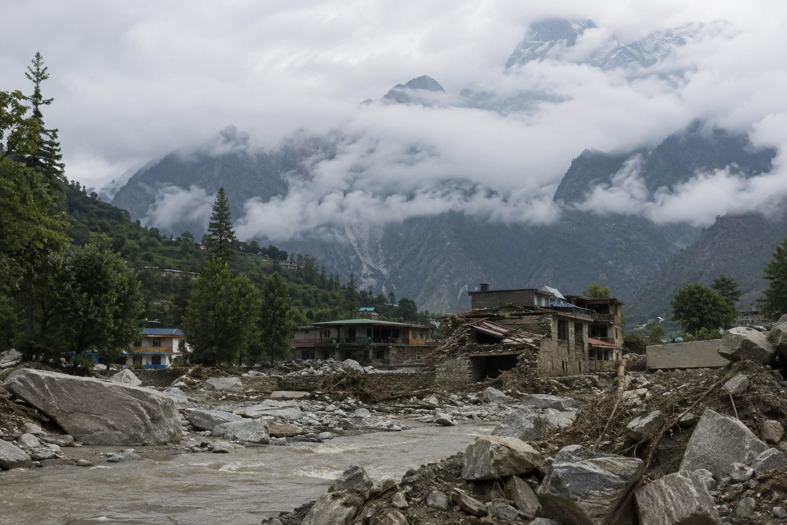
The Himalayas are not simply the highest mountain system on Earth. They are one of the planet’s most active geological and climatic hazard zones, where earthquakes, monsoon rainfall, collapsing glaciers, landslides and avalanches can interact within hours.
That distinction matters.
A Himalayan disaster is rarely just an earthquake or a flood. A magnitude 7.8 earthquake can trigger thousands of landslides. A collapsing glacier can become a high-speed debris flow. A few days of extreme rainfall can turn pilgrimage routes into channels of rock, mud and water. And warming temperatures are altering the frozen ground that has helped stabilize some of the highest terrain.
The scale of the exposure is enormous. The Hindu Kush Himalaya region supports water systems on which nearly two billion people depend, while ICIMOD’s latest assessments show that glacier ice loss has accelerated sharply since 2000.
The Himalayas are therefore best understood as a connected system of peaks, rivers, glaciers, settlements, pilgrimage corridors and infrastructure. When one part fails, the consequences can travel far downstream.
What is the Himalayan range and where does it extend?
The Himalayas form a vast mountain arc across South Asia, stretching through Pakistan, India, Nepal, Bhutan and China, with the wider Hindu Kush Himalayan system extending farther west and east.
Geologically, the range exists because the Indian Plate continues to push northward into the Eurasian Plate. That collision is still active. The result is not a static mountain range but a landscape under continuing tectonic stress.
This is the fundamental reason the Himalayas remain earthquake-prone.
It also explains why steep slopes are so unstable. Young, rapidly uplifted mountains contain fractured and weathered rock, while enormous differences in elevation create extreme gradients for rivers and debris flows. Add monsoon rainfall, snow, glaciers, permafrost and expanding infrastructure, and the ingredients for cascading disasters are already present.
The highest and most important Himalayan peaks
Mount Everest is the best-known summit, but the Himalayan landscape is defined by a much larger collection of major peaks.
Mount Everest
At 8,848.86 metres, Mount Everest is Earth’s highest mountain above sea level. It is known as Sagarmatha in Nepal and Chomolungma in Tibet.
Everest’s prominence makes it a symbol of mountaineering, yet the mountain’s most dangerous zones are often not the summit itself. The Khumbu Icefall, with its unstable blocks of glacial ice, has repeatedly produced fatal avalanches.
The 2014 Khumbu Icefall avalanche killed 16 Nepali mountaineering workers, making it the deadliest single accident in Everest climbing history.
Kangchenjunga
At 8,586 metres, Kangchenjunga is the world’s third-highest mountain and dominates the eastern Himalayas on the Nepal-Sikkim border.
Its surrounding terrain is particularly important when studying Himalayan hazards because eastern Himalayan slopes receive intense precipitation and are highly susceptible to landslides.
Lhotse
Lhotse rises to 8,516 metres immediately south of Everest. Its proximity to Everest means that the two mountains share some of the same high-altitude hazards, including severe weather, avalanche exposure and rapidly changing ice conditions.
Makalu
At 8,485 metres, Makalu is one of the world’s highest peaks. Its isolated location and steep terrain make it a particularly demanding mountaineering environment.
Dhaulagiri
Dhaulagiri I reaches 8,167 metres in Nepal. The surrounding region is exposed to avalanches, extreme snowfall and severe mountain-weather events.
Manaslu
At 8,163 metres, Manaslu is another major Nepalese peak. The mountain and its trekking corridor demonstrate an important point about Himalayan risk: disaster exposure is not restricted to climbers attempting 8,000-metre summits. Villages, trekking routes, roads and river valleys below them can be equally vulnerable.
Why are the Himalayas so prone to natural disasters?
Four forces interact across the range.
First is tectonic activity. The India-Eurasia collision makes major earthquakes a persistent threat.
Second is topography. Himalayan rivers descend enormous vertical gradients. A landslide or collapsing glacier can therefore accelerate rapidly as it moves downhill.
Third is water. The region experiences intense monsoon rainfall while storing enormous quantities of frozen water in glaciers and snowfields.
Fourth is a changing climate.
ICIMOD reported in 2023 that Himalayan glaciers were losing mass 65 percent faster during 2011–2020 than during the previous decade. Its 2026 assessment found that glacier ice-loss rates have continued accelerating, with some glaciers losing up to 27 metres of ice thickness since 1975.
The result is a complicated hazard chain:
Extreme rainfall → slope failure → landslide → river blockage → sudden flood.
Earthquake → thousands of landslides → blocked valleys → secondary floods.
Glacier instability → ice or rock collapse → glacial lake outburst flood → debris flow.
That cascading character is what makes Himalayan disasters unusually difficult to manage.
Which Himalayan areas are most prone to natural disasters?
Risk is not distributed evenly.
Uttarakhand
The Garhwal Himalayas contain some of India’s most important pilgrimage routes, including Kedarnath and Badrinath. They also contain steep valleys, glaciers, hydropower projects, roads and densely used pilgrimage corridors.
The 2013 Uttarakhand disaster demonstrated how quickly these factors can interact.
Nepal’s central Himalayas
Central Nepal sits directly above the Main Himalayan Thrust and has experienced devastating earthquakes, landslides and floods.
The Kathmandu Valley is especially exposed because a large population lives in an earthquake-sensitive basin surrounded by steep terrain.
Sikkim and the eastern Himalayas
Sikkim and the Darjeeling Himalayas combine steep slopes with intense rainfall and seismic activity.
Research on the eastern Himalayan region identifies rugged topography, fragile rock formations, intense precipitation and high seismicity as major drivers of landslide activity.
Kashmir and Himachal Pradesh
The western Himalayas face earthquakes, avalanches, landslides, flash floods and heavy snowfall. Major transport corridors through narrow valleys can be cut off by a single large slope failure.
Northern Pakistan
The Karakoram and western Himalayan region faces an especially complex combination of glaciers, steep slopes, earthquakes and landslide-dammed rivers.
This is also where the distinction between the Himalayas proper and the wider Hindu Kush-Karakoram-Himalayan system becomes important. Some of the world’s most severe mountain disasters occur in this broader high-mountain belt rather than within the strict geographic definition of the Himalayan range.
The Himalayas’ most important pilgrimage destinations
Religion has created some of the world’s oldest and busiest human corridors through high mountain terrain.
Kedarnath
At roughly 3,580 metres, Kedarnath is one of India’s most important Shiva pilgrimage sites and part of the Char Dham circuit. It sits beside the Mandakini River and below major Himalayan peaks.
Its importance also makes it a case study in disaster exposure. Thousands of pilgrims can occupy narrow mountain valleys at the same time, precisely where flash floods and landslides have limited escape routes.
Badrinath
Badrinath, at approximately 3,100 metres, is one of the Char Dham destinations and is dedicated to Vishnu. It lies beside the Alaknanda River between the Nar and Narayana mountain ranges.
Gangotri and Yamunotri
These two Uttarakhand pilgrimage destinations are associated with the sources of the Ganga and Yamuna river systems and attract large numbers of pilgrims during the pilgrimage season.
Amarnath
The Amarnath cave in Jammu and Kashmir is among India’s most famous high-altitude pilgrimage destinations. The route traverses terrain exposed to sudden weather changes, landslides and flash floods.
Mount Kailash and Lake Manasarovar
In Tibet, Mount Kailash has extraordinary religious importance to Hindus, Buddhists, Jains and followers of the Bon tradition.
Its pilgrimage routes cross some of the most remote and environmentally sensitive terrain in the Himalayan region.
The significance of these routes became painfully clear during the August 2026 Nepal-Tibet disaster, when pilgrims and tourists travelling toward the Kailash region were among those caught in catastrophic flooding. At the time of writing, rescue operations remain underway and casualty figures are still changing.
The 10 most devastating natural and climatic disasters in Himalayan history
There is no single authoritative ranking because historical records are incomplete and the geographic definition of “Himalayan” varies. The following list therefore focuses on disasters with exceptional death tolls, geographic impact or importance to understanding Himalayan risk.
1. The 1905 Kangra earthquake
On 4 April 1905, a major earthquake struck the Kangra Valley in what is now Himachal Pradesh.
Historical estimates put the death toll at around 20,000, although modern assessments have revised the earthquake’s magnitude from some early estimates of 8.6 toward approximately 7.8.
The disaster remains one of the defining seismic events of the western Himalayas.
Its lesson is straightforward: the region’s earthquake danger is not theoretical or confined to Nepal.
2. The 1934 Bihar-Nepal earthquake
On 15 January 1934, an earthquake of roughly magnitude 8 struck Nepal and northern India.
Estimated deaths range from approximately 10,700 to 12,000. The destruction extended across a huge area, with severe damage in Kathmandu and northern Bihar.
The event is particularly important because it demonstrates how a Himalayan earthquake can produce catastrophic losses well outside the high mountains.
3. The 1950 Assam-Tibet earthquake
The 15 August 1950 earthquake is generally regarded as the largest instrumentally recorded earthquake associated with the Himalaya and surrounding region, at about magnitude 8.6 to 8.7.
Approximately 4,800 deaths have been reported across Assam and Tibet, although historical casualty estimates remain uncertain. The earthquake triggered enormous landslides and river blockages, showing how seismic shaking can generate hydrological disasters downstream.
4. The 1968 Sikkim-Darjeeling floods and landslides
From 2 to 5 October 1968, extraordinary rainfall battered Sikkim and the Darjeeling region.
Around 1,000 people were killed or went missing, while landslides destroyed roads, bridges and settlements. Historical accounts record extremely intense rainfall over short periods.
The event remains one of the clearest historical demonstrations of the eastern Himalayas’ exposure to rainfall-driven landslide disasters.
5. The 1998 Malpa landslide
On 18 August 1998, a massive landslide destroyed Malpa village in the Kumaon Himalayas.
About 221 people died, including pilgrims travelling toward Tibet on the Kailash Mansarovar route.
Malpa illustrates a recurring Himalayan problem: pilgrimage corridors often run through exactly the valleys where geology, slope angle and rainfall create the greatest danger.
6. The 2013 Uttarakhand floods
The June 2013 disaster was among the most devastating Himalayan hydrological events in modern Indian history.
Heavy rainfall, cloudbursts, flash floods and landslides struck Uttarakhand on 16–17 June. India’s Ministry of Home Affairs initially recorded hundreds of confirmed deaths and thousands missing. Later official assessments placed the number presumed dead above 5,700.
The tragedy was amplified by the concentration of pilgrims and tourists in narrow valleys.
The most important lesson was not simply that extreme rainfall can kill. It was that exposure matters. Roads, hotels, bridges, settlements and pilgrimage infrastructure had expanded into terrain where rivers and debris flows already had natural pathways.
7. The 2014 Annapurna snowstorm and avalanche disaster
On 14 October 2014, an unusually severe snowstorm associated with Cyclone Hudhud struck central Nepal.
At least 43 people died on and around the Annapurna Circuit, including trekkers and local mountain workers. More than 500 people were rescued.
It remains one of Nepal’s worst trekking disasters.
The event also showed why weather forecasting in mountain environments is not a luxury. A storm system that begins hundreds of kilometres away can produce lethal conditions at high altitude.
8. The 2015 Gorkha earthquake
On 25 April 2015, a magnitude 7.8 earthquake struck central Nepal.
Approximately 9,000 people died and more than 23,000 were injured. More than 500,000 houses were destroyed, while another 269,000 were damaged.
The earthquake also triggered thousands of landslides. USGS researchers mapped 4,312 earthquake-related and post-earthquake landslides in one major assessment.
The disaster exposed a crucial distinction between hazard and vulnerability. The earthquake itself was devastating, but poorly reinforced buildings dramatically increased the human toll.
9. The 2021 Chamoli rock-ice avalanche
On 7 February 2021, a massive collapse from Ronti Peak in Uttarakhand released approximately 27 million cubic metres of rock and glacier ice.
The material transformed into a highly mobile debris flow that raced through the Rishiganga and Dhauliganga valleys. More than 200 people were killed or remained missing, and two hydropower projects were severely damaged.
The event changed scientific understanding of Himalayan hazards because it demonstrated how a seemingly remote high-altitude slope failure can rapidly become a destructive valley-floor disaster.
10. The 2023 South Lhonak glacial lake outburst flood
On 4 October 2023, a massive failure involving the South Lhonak glacial lake system in Sikkim generated a catastrophic flood through the Teesta valley.
Later scientific research found that a large section of the lake’s lateral moraine had been moving at more than 15 metres per year between 2016 and 2023. The collapse generated a wave roughly 20 metres high and released an enormous volume of water downstream.
The event killed at least 55 people, with 70 still missing in the assessment cited by ICIMOD, while hydropower infrastructure, bridges and highways were extensively damaged.
It is a warning about the new Himalayan hazard equation: climate change does not need to create an entirely new disaster type. It can destabilize the conditions that make existing hazards more likely.
The newest Himalayan warning is unfolding now
The history of Himalayan disasters has not stopped at 2023.
On 26 August 2026, a catastrophic flash flood struck the Nepal-Tibet border after a massive collapse involving ice and rock. As rescue operations continue, reports indicate at least 165 confirmed deaths and nearly 1,500 people missing across Nepal and Tibet. Many of the missing are foreign tourists and pilgrims travelling toward the Kailash region.
The precise trigger and final casualty count remain under investigation.
What is already clear is the pattern. A high-mountain collapse generated a rapidly moving flood that destroyed roads, bridges, settlements and critical infrastructure. The disaster also exposed a modern vulnerability that did not exist at the same scale a century ago: remote Himalayan valleys now carry large volumes of tourism, pilgrimage, hydropower and transport infrastructure.
Climate change is changing the risk, not eliminating the old risks
It would be simplistic to label every Himalayan disaster a “climate disaster.”
Earthquakes are tectonic. Landslides have always occurred. Avalanches are part of mountain systems.
The change lies in the background conditions.
The HKH cryosphere is warming. Glaciers are shrinking, permafrost is thawing and snowfall patterns are becoming less predictable. ICIMOD’s 2023 assessment warned that Himalayan glaciers could lose as much as 80 percent of their current volume by the end of the century under high-emissions trajectories.
The practical consequence is a shifting risk profile.
Some glaciers retreat and reduce long-term water storage. Some glacial lakes grow. Some slopes lose frozen material that once helped stabilize them. Extreme rainfall can then interact with increasingly unstable terrain.
The danger is not simply “more floods.”
It is more complicated: changing ice conditions, unstable slopes, extreme precipitation and expanding human infrastructure can combine to create disasters that move faster than traditional emergency systems can respond.
The real Himalayan risk is the cascade
The most important conclusion from Himalayan disaster history is that individual hazards should not be studied in isolation.
The 2015 earthquake generated landslides.
The 2021 Chamoli collapse transformed rock and ice into a debris flow.
The 2023 Sikkim event combined glacial instability, flooding, landslides and infrastructure failure.
The 2013 Uttarakhand disaster showed how extreme rainfall can collide with concentrated pilgrimage and tourism activity.
This is why future Himalayan risk management cannot focus only on building stronger roads or issuing better weather forecasts. It requires integrated monitoring of glaciers, lakes, slopes, rainfall, seismic activity, river levels and human settlement.
The Himalayas are still rising. Their glaciers are changing. Their rivers are carrying more sediment in many vulnerable valleys. Their population and infrastructure footprint is growing.
The central question for the next generation is not whether the Himalayas will produce another catastrophic earthquake, flood, landslide or glacier collapse. They will.
The real question is whether governments, infrastructure planners, pilgrimage authorities and communities will recognize the Himalayas as a dynamic hazard system before the next cascade begins.
References & Sources
International Centre for Integrated Mountain Development, “Water, Ice, Society, and Ecosystems in the Hindu Kush Himalaya: An Outlook”
https://lib.icimod.org/record/36322
International Centre for Integrated Mountain Development, “Hindu Kush Himalaya glaciers losing ice at double the rate since 2000”
https://www.icimod.org/press-releases/hindu-kush-himalaya-glaciers-losing-ice-at-double-the-rate-since-2000-new-icimod-report-confirm/
International Centre for Integrated Mountain Development, “New scientific study confirms climate change played key role in deadly 2023 lake outburst in Sikkim”
https://www.icimod.org/press-release/new-scientific-study-confirms-climate-change-played-key-role-in-deadly-2023-lake-outburst-in-sikkim/
U.S. Geological Survey, “A massive rock and ice avalanche caused the 2021 disaster at Chamoli, Indian Himalaya”
https://www.usgs.gov/publications/a-massive-rock-and-ice-avalanche-caused-2021-disaster-chamoli-indian-himalaya
U.S. Geological Survey, “M7.8 Nepal Earthquake, 2015 – A Small Push to Mt. Everest”
https://www.usgs.gov/programs/earthquake-hazards/science/m78-nepal-earthquake-2015-a-small-push-mt-everest
U.S. Geological Survey, “Geomorphic and geologic controls of geohazards induced by Nepal’s 2015 Gorkha earthquake”
https://www.usgs.gov/publications/geomorphic-and-geologic-controls-geohazards-induced-nepals-2015-gorkha-earthquake
U.S. Geological Survey, “Assessment of existing and potential landslide hazards resulting from the April 25, 2015 Gorkha, Nepal earthquake sequence”
https://pubs.usgs.gov/publication/ofr20151142
Government of India, Ministry of Home Affairs, “Year End Review-2013”
https://www.pib.gov.in/newsite/PrintRelease.aspx?relid=102166
Uttarakhand Tourism, “Kedarnath”
https://www.uttarakhandtourism.gov.in/explore/kedarnath
Uttarakhand Tourism, “Badrinath”
https://www.uttarakhandtourism.gov.in/destination/badrinath
Shri Badarinath Kedarnath Temple Committee
https://badrinath-kedarnath.gov.in/
The Himalayan Club, “The Great Himalayan Earthquakes”
https://www.himalayanclub.org/hj/62/5/the-great-himalayan-earthquakes/
Reuters, “Death toll in Nepal’s worst trekking disaster reaches 43”
https://www.reuters.com/
Reuters, “Deadly disasters in the Himalayas over a dozen years”
https://www.reuters.com/business/environment/deadly-disasters-himalayas-over-dozen-years-2026-08-26/
Reuters, “Rescuers seek nearly 1,500 still missing in Nepal and China after flash flood”
https://www.reuters.com/business/environment/rescuers-search-survivors-after-devastating-nepal-flood-2026-08-27/
Associated Press, “Floods caused by a glacial collapse kill at least 160 people on Nepal-China border”
https://apnews.com/
Natural Hazards and Earth System Sciences, “Estimating and predicting natural hazards and vulnerabilities in the Himalayan region”
https://nhess.copernicus.org/articles/24/3291/
About The Author


