
Dharali region devasted, civilians killed, past disasters like Kedarnath (2013) and Chamoli (2021) recalled.
By Namith DP | August 06, 2025
Introduction
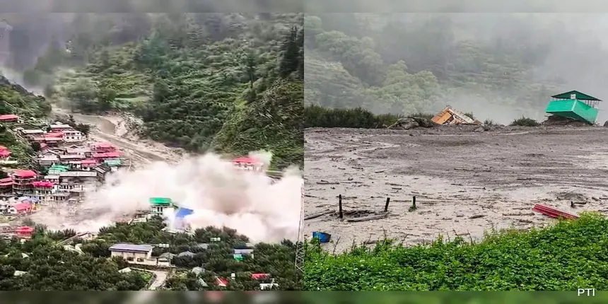
On 5 August 2025, an intense cloudburst struck Dharali, a Himalayan village in Uttarkashi district, triggering a sudden flash flood. Torrents of rain cascading down the Kheer Ganga River basin obliterated homes, shops, hotels, and infrastructure. Authorities confirmed at least four fatalities and over 100 people missing. The Indian Army, NDRF, SDRF, and local volunteers launched a coordinated rescue operation. This catastrophic event underscores the escalating challenges of climate-driven extreme rainfall, unregulated development, and inadequate disaster preparedness in Uttarakhand. Analysis of past incidents like Kedarnath (2013) and Chamoli (2021) provides essential context and lessons for preventing future tragedies.
Timeline & Impact

Event Summary
- Date and Time: 5 August 2025, ~1:45 PM IST
- Epicenter: Upper catchment of Kheer Ganga River, affecting Dharali, Harsil region
- Rainfall: IMD recorded ~212 mm in 24 hours, over 400% above normal monsoon levels — meeting “cloudburst” criteria (≥100 mm/hour)
Damage Overview
- Fatalities: 4 confirmed
- Missing: Approx. 50–100 individuals unaccounted for as of 6 August
- Infrastructure:
- Entire Dharali market, hotels, homestays, and road sections wiped out
- Army camp helipad, power lines, and bridges collapsed
- Banala Patti area saw 18 goats washed away
Rescue Efforts
- Evacuations: Over 130 people rescued within 24 hours
- Techniques: Use of sniffer dogs, ground-penetrating radar, and heavy machinery
- Government coordination: High-alert declarations by Chief Minister Dhami; federal assistance and helpline support (+91‑94565‑56431) established
Why Dharali Was at High Risk
Geographic & Environmental Vulnerabilities
- Located in a steep Himalayan valley with narrow drainage channels
- Fragile geology and absence of natural flood buffers made it prone to sudden flash floods
Climatic Trends
- According to a recent study, Uttarakhand is now an “emerging hotspot for extreme climate events”
- Since 2010, sharp increase in cloudbursts driven by local moisture convergence, shifting monsoon dynamics, and rising temperatures (>0.16 °C per decade)
Uncontrolled Development
- Illegal guesthouses, retaining walls, roads built along rivers limited natural water absorption
- Tourism infrastructure encroached on drainage zones, compounding flood impact and reducing response time
Historical Comparisons
2013 Kedarnath Cloudburst & Flood
- Date: 16–17 June 2013
- Fatalities: ~6,054 total; ~89% occurred in Uttarakhand, including Kedarnath (government figure)
- Scale: ~4,550 villages affected; severe mountain flooding trapped ~300,000 pilgrims; over 110,000 evacuees
- Causation:
- Persistent cloudburst, snowmelt, and moraine lake outburst from Chorabari (Gandhi Sarovar) Lake, releasing ~212 million liters in under 10 minutes
- High concentration of hydroelectric and tourism infrastructure accelerated damage
- Lessons not fully implemented, resulting in repeated vulnerability
2021 Chamoli Flash Flood
- Date: 7 February 2021
- Cause: Massive ice-rock avalanche triggered the Rishiganga and Dhauliganga rivers, devastating the Tapovan–Rishiganga hydropower projects
- Fatalities: Over 200 missing or confirmed dead; extensive destruction of hydropower infrastructure and bridges; 13 villages disconnected
- USDMA report identified “sequential intermittent damming”—streams blocked repeatedly upstream—caused sudden water release
- Outcome: Entire power projects wiped out despite previous warnings; post-disaster environmental assessments remained inadequate
Comparative Overview
| Year | Location | Cause | Fatalities | Impact Scale |
|---|---|---|---|---|
| 2013 | Kedarnath (Uttarkashi) | Cloudburst + lake outburst | ~6,000 | Multi-thousand sq km, large pilgrimage impact |
| 2021 | Chamoli (Garhwal) | Avalanche + stream damming | ~200+ | Hydropower destruction, village loss |
| 2025 | Dharali (Uttarkashi) | Localized cloudburst | 4 confirmed, ~100 missing | Village-level destruction, hotels, camps |
Broader Climate & Regional Trends
Sharp Rise in Events
- Government data shows 7,750 cloudburst or extreme rainfall events since 2015, causing 230 deaths and widespread landslides across Uttarakhand
- Scientific consensus cites a spike post‑2010 in extreme weather due to regional climate shifts, Nepal glacial melt, ENSO and Indian Ocean Dipole interactions, and local orographic moisture dynamics
Urbanization & Political Discontinuity
- Frequent leadership change and ad-hoc development eliminated long-term disaster planning and regulations
- IMD lacked Doppler radars in the region until 2021; planning failed to account for Himalayan-specific precipitation patterns
Expert Recommendations & Structural Solutions

System-Wide Reforms
- Expand Early Warning Systems
- Deploy Doppler radars proximal to critical catchments (e.g., Mukteshwar, Lansdowne)
- Install Automated Rainfall Gauge Network across high-risk districts
- Mandate Hazard Zoning
- Enforce minimum 200 m setback from river banks
- Classify and restrict flood-risk zones in Panchayat master plans and infrastructure permits
- Audit Mega-Projects
- Impose independent risk assessment protocols for hydropower, tunnel, and road projects
- Require legally binding environmental clearance with geological hazard data and disaster mitigation plans
- Strengthen Local Response Capacity
- Train village-level first responders, volunteers, and schools in cloudburst protocols
- Conduct biannual mock drills, integrated with NDRF/SDRF coordination
- Climate-Resilient Livelihood Planning
- Encourage alternative livelihoods beyond tourism in eco-sensitive zones
- Launch awareness campaigns highlighting flood indicators, evacuation routes, and early warning signals
Lessons Learned & Policy Imperatives
- Kedarnath (2013) exposed large-systemic failures: tunnel blasting, river compression, unchecked tourism development. Yet reforms remained partial.
- Chamoli (2021) showed that avalanche-induced “damming” can produce floods even in low-rainfall winter periods. Risk assessment for glacial-impacted infrastructure remained incomplete.
- Dharali (2025) reinforces that localized cloudbursts now produce flash floods at minute scale, requiring hyper-local detection and response capacity.
- Authorities must shift from reactive to proactive models: integrate geological vulnerability with climate forecasts, ahead-of-time community evacuation plans, and enforcement of eco-sensitive building codes.
Conclusion
The Aug 5, 2025 cloudburst in Uttarkashi illustrates that Uttarakhand now lies on the frontline of climate-induced disasters. Its 4 confirmed deaths, ~100 missing, and sweeping destruction of infrastructure mirror earlier tragedies in Kedarnath (2013) and Chamoli (2021), yet represent a trend toward increasing frequency and intensity.
Without reforms in early warning systems, zoning enforcement, and development governance, the state will continue to suffer high casualties and economic losses. Historical comparisons confirm that past lessons remain partially unimplemented. Climate adaptation and disaster resilience must become legal imperatives rather than policy rhetoric.
In urgent response, authorities must prioritize real-time rainfall monitoring, pre-disaster local training, and risk-based infrastructure review. Only then can Uttarakhand mitigate the growing threat posed by its fragile geography and changing climate.


Hope all those who are affected receive aid soon
[…] Cloudburst in North India leaves 4 dead and many injured […]